Marcellus | NGI All News Access
USGS Releases Land Disturbance Data in Pennsylvania
The U.S. Geological Survey (USGS) released the latest in a series of reports analyzing land disturbance from natural gas drilling over a six-year period in Pennsylvania on Wednesday, and it plans to release another report covering nearly half the state by the end of the year.
Researchers at the USGS used data from the National Agriculture Imagery Program to study patterns of landscape disturbance, including land cover and land use, from 2004 to 2010 in 14 Pennsylvania counties with both Marcellus Shale and non-Marcellus Shale gas drilling. The agency also took note of changes in forestation.
Lesley Milheim, physical scientist for the USGS and one of the authors of the seven reports, said their analysis is intended to serve as a “kind of a monitoring effort” for parties interested in natural gas development, especially environmental groups, but also industry groups.
“This series of reports is really to document the disturbance that has taken place during that time period,” Milheim told NGI’s Shale Daily on Thursday. “We want this data to be taken up by other groups who have a particular ecological endpoint or interest to use it in order to evaluate their particular interests. Anyone can use it to evaluate their particular interests; there’s no particular bias there.”
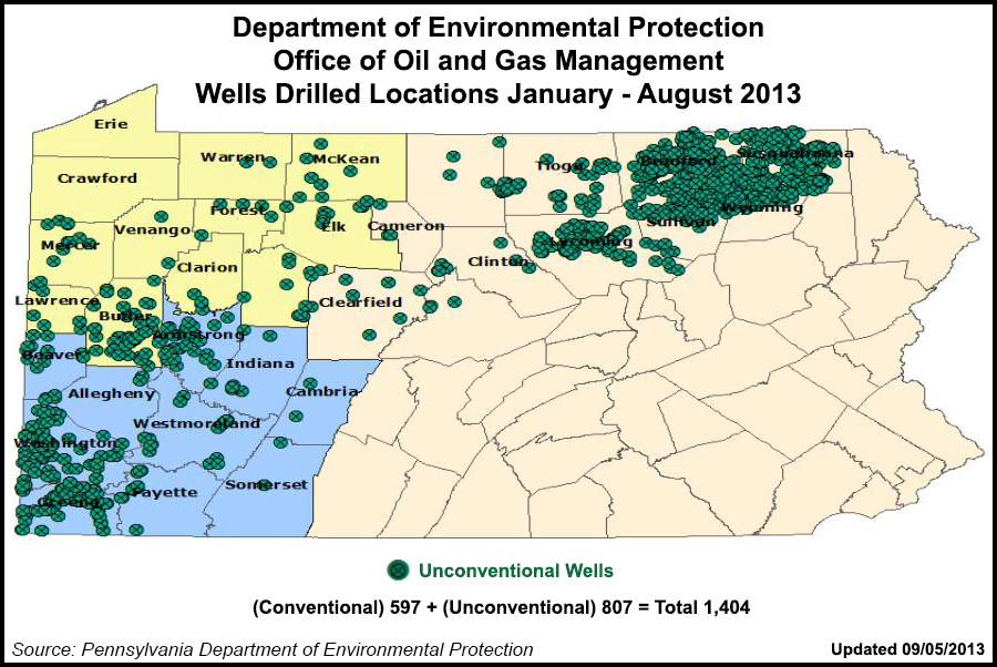
According to Pennsylvania Department of Environmental Protection data, as of Sept. 5, a total of 1,404 wells have been drilled so far during 2013 in Pennsylvania, with 807 of them being unconventional wells.
The USGS paired two counties for each of the seven reports. On Wednesday, two reports pairing Beaver and Butler counties, and Lackawanna and Wayne counties, were released. Previous reports paired Somerset and Westmoreland, Fayette and Lycoming, Allegheny and Susquehanna, Greene and Tioga, and Bradford and Washington counties. The first reports were released in September 2012.
“There are two hots spots for development as far as the Marcellus goes,” Milheim said. “One is in the southwest, primarily in Washington and Greene counties. Then there is one in the northeast, in Bradford and Susquehanna counties.”
In Greene County, the USGS researchers found disturbance mostly on the eastern side of the county, but there was some activity in the north and south and minor activity in the west. By comparison, disturbance in Washington County was found in two clusters, from mostly Marcellus activity in the northwest and mostly non-Marcellus in the southeast. The researchers found that in Susquehanna County most of the drilling activity was targeting the Marcellus.
“On the other hand, Bradford County shows most of the disturbance at the western portion of the county, with some minor disturbance in the east,” the USGS said. “With the accompanying areas of disturbance, well pads, new roads, and pipelines from both types of natural gas wells, the effect on the landscape is often dramatic. These landscape effects have consequences for the ecosystems, wildlife, and human populations that are collocated with natural gas extraction activities.”
Milheim added that during her time working on the reports, “I could see that [natural gas development] fragments the forests in different ways, depending on whether its Marcellus or conventional. They produce two different types of footprints. It takes down trees, it cuts roads through, it does impact the forest.”
According to Milheim, the USGS’ final report will be released before year’s end, analyzing 30 of Pennsylvania’s 67 counties in the Marcellus Fold Belt. “It will be a broad picture of what happened in that central part of the state between 2004 and 2010,” she said.
Two bills introduced this summer in the Pennsylvania General Assembly would make it more difficult to list and protect endangered species in the state, including those affected by land disturbance and potentially at risk (see Shale Daily, Sept. 11). The bills, HB 1576 and SB 1047, are currently in committee and are backed by the oil and gas industry and its supporters.
© 2024 Natural Gas Intelligence. All rights reserved.
ISSN © 2577-9877 | ISSN © 2158-8023 |
