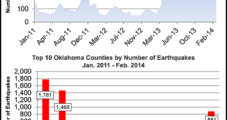
Twenty-six small earthquakes have rattled the state of Oklahoma over the past week — including seven on Saturday alone — according to data from the U.S. Geological Survey (USGS).
Usgs
Articles from Usgs
NC State Senator: Shale Bill Has Good Chance at Becoming Law
A bill that would lift North Carolina’s moratorium on hydraulic fracturing (fracking) and open the Tar Heel State to shale development has passed the state Senate and stands a good chance of being signed into law by Gov. Pat McCrory, according to one of the bill’s primary sponsors.
May 23, 2014
Geologic, Regulatory Aftershocks from Latest Oklahoma Quakes
More earthquakes jolted parts of central Oklahoma Saturday, prompting added speculation about the ties between the quakes and oil and natural gas drilling wastewater injection processes. Although small in magnitude — measuring 2.6-4.0 on the Richter Scale — the frequency of the tremors has already surpassed 2013 totals, according to the Oklahoma Geological Survey (OGS).
April 8, 2014
Injection Wells Thought Behind Oklahoma Quaking
Since the beginning of 2009, Central Oklahoma has experienced a substantial increase in seismic activity, too much to be random, researchers think. Drilling wastewater disposal in injection wells is a likely contributing factor, they said.
October 25, 2013
Industry Brief
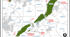
Pennsylvania State Universityresearchers who have been charged with monitoring 21 seismograph stations across the state are also reportedly studying the geological structure of the South Newark Basin. The $269,000 study is part of a federal program to research earthquakes nationwide, and was contracted to the university by theDepartment of Conservation and Natural Resources(DCNR) this summer, according to Philadelphia’sIntelligencernewspaper, which gathered the information through a series of right-to-know requests. In 2012 theU.S. Geological Survey(USGS) said the South Newark was one of three Mesozoic shale basins along the East Coast with the “most resource potential” for oil and gas producers (seeShale Daily,June 21, 2012). There is a 95% chance that at least 363 Bcf of undiscovered natural gas is locked in the formation, along with 1 million bbl of undiscovered natural gas liquids, USGS said. Following the USGS report, the General Assembly days later adopted a drilling moratorium for the South Newark Basin, which is located across upscale, ex-urban Philadelphia counties (seeShale Daily,July 3, 2012). The legislation forbid the state’sDepartment of Environmental Protectionfrom issuing well permits in the basin until DCNR completed a study of “the practical resource recovery implications” of the USGS report and the fiscal impact of oil and gas operations in the basin. Oil and gas operations in the South Newark Basin are already restricted by theDelaware River Basin Commission’s de facto moratorium on exploration and development (see Shale Daily,June 16, 2010).
October 3, 2013
USGS Offers Details on California Seafloor
USGS said the “California Seafloor Mapping Program” has peeled back “a veil of water just offshore of California,” revealing the ocean’s floor in significantly new detail. “New imagery, specialized undersea maps, and a wealth of data from along the California coast are now available,” a USGS spokesperson said.
August 14, 2013
Listen to the latest episode of our newest podcast NGI's Hub and Flow via: