North Dakota University Researchers Debunk Space Shots of Bakken Flaring
Satellite photographs that purported to show light of wellhead natural gas flaring in the Bakken Shale more intense than that of major metropolitan areas were mischaracterized and distorted, according to researchers at the University of North Dakota’s (UND) Energy and Environmental Research Center (EERC).
Since the satellite photos began making the rounds on the internet two years ago, research by Chris Zygarlicke, deputy associate EERC director, and the university’s aerospace department determined that the images were actually representations of heat sources — not light.
“Results of this work suggest that popular satellite images of North Dakota’s night sky are a result of highly processed data from highly sensitive sensors that amplify light and heat sources from a variety of sources, including manufacturing plants, residences, construction sites, and gas production activities,” Zygarlicke said.
The UND researchers used images from the National Oceanic and Atmospheric Administration (NOAA) to determine what the state’s active oil patch really looks like from outer space. The North Dakota Industrial Commission was shown those images at its meeting earlier this month and the Department of Mineral Resources (DMR) was briefed in late May.
A DMR spokesperson said state energy officials found the EERC information “very interesting,” but they do not intend to do anything as a result of clarifying analysis by the university groups. A state program to get greater levels of gas capture from producers (see Shale Daily, April 13; June 2, 2014) will continue unchanged, the spokesperson said.
Among the findings of the $25,000 research project by EERC and the UND John Odegard School of Aerospace Science was the fact that the satellite images amplified the actual brightness in North Dakota by more than 100 times.
“The images are misleading in that they give the [general public] the idea that flares are literally lighting up many square miles of prairie countryside, creating visible light similar to large metro areas,” according to the study. “A casual drive on any evening through counties of the Bakken oil play show otherwise, so how are these satellite images being formulated?”
The UND researchers said they had developed a better way to identify, characterize and process gas flaring images based on NOAA data.
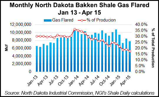
The percentage of gas produced in North Dakota from the Bakken Shale that is flared has been in steady decline since the end of 2013. The amount of production flared has fallen from a peak of 36.4% in December 2013 to 17.8% in April 2015, and has been below 20% for most of 2015.
© 2024 Natural Gas Intelligence. All rights reserved.
ISSN © 2577-9877 | ISSN © 1532-1266 | ISSN © 2158-8023 |