Blustery Winter Muscles In, Knocking Out Mild Conditions, Says Forecaster
The eastern United States is on the cusp of a much colder pattern that is forecast to prevail in February and continue into March because of a central Pacific El Nino, which is seen slowly weakening through summer, according to forecaster DTN.
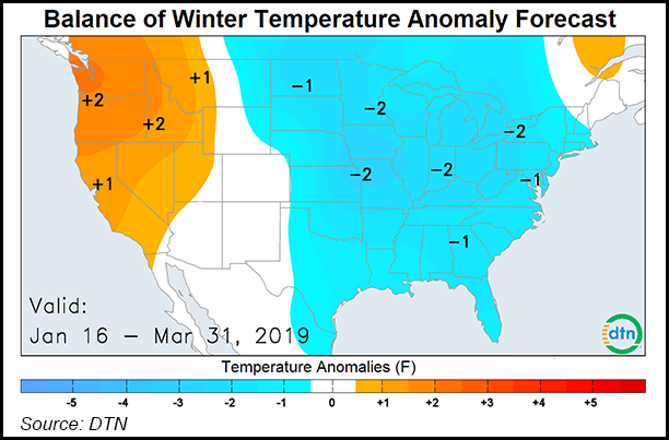
Colder-than-normal temperatures are most likely from the north-central United States into the southeastern part of the country, while the West is expected to see much milder conditions overall, long-range forecast team lead Nathan Hamblin said Wednesday in a webinar.
After a far milder-than-normal December to mid-January period, Week 2, beginning Sunday through Jan. 26, is forecast to see the flip to colder conditions as the jet stream intensifies, but the worst of the bone-chilling temperatures will likely hit the United States during Week 3. Week 4 is expected to see some warmth starting to build in the West, although the eastern United States will likely remain cold, according to long-range forecasts.
“The winter chill will linger into March east of the Rockies” with cold and snow slow to end, Hamblin said. Some of the chilliest conditions were expected in the southern Plains, while the most precipitation was forecast to fall over the Southwest, California and the Gulf Coast.
The shift to a much more frigid pattern comes as Arctic air from Canada is forecast to spread south more frequently for the rest of the winter, especially from North Carolina into the southeastern United States. Meanwhile, any milder breaks in the cold pattern are expected to be more limited during the rest of the winter, Hamblin said.
The polar vortex, a notorious swirl of winds around a low pressure area in the upper atmosphere over the Arctic, split a few weeks ago, according to DTN. “This was pretty extreme,” said certified consulting meteorologist Jeff Johnson.
A polar vortex tends to be associated with some of the coldest air during the winter, and current indications are that the recent split will be of long duration, lasting six to eight weeks before it’s resolved, Johnson said. While this winter — even with bitter weather expected to last into March — is expected to see overall heating degree days average in line with historical norms, the “potential is there for cold to become extreme for a while, and heating degree day totals could swing back to above normal,” Hamblin said.
Meanwhile, DTN is projecting highly variable snowfall totals for the remainder of the winter, although “there is still snow coming for a lot of the country,” Hamblin said, especially in the Four Corners region and the northern Rockies. The Great Lakes is expected to see below-average snowfall, although some lake effect snow is likely.
“There will be haves and have nots in these storm patterns,” Hamblin said.
Meanwhile, the Ohio and Tennessee Valleys are forecast to see lighter-than-average precipitation, and coastal storm threats are expected to continue along the upper East Coast through March. Texas and areas across the southeastern United States were expected to be both wetter and colder during that time.
“Mixed precipitation types will be a threat farther south this winter due to more cold air intrusions,” Hamblin said.
The cold, wet weather could cause some concern for Permian Basin producers, as midstream companies not used to dealing with such conditions have not invested as much in line insulation and freeze prevention, according to Genscape Inc.
“That said, the Permian really only had one major freeze-off event last winter right after the new year,” Genscape senior natural gas analyst Rick Margolin said. “That event took out about 6 Bcf over a four-day period, with one day losing 2 Bcf.”
By April, DTN sees the weather pattern reversing, keeping cold air trapped in the West, while the Lower Mississippi is expected to be wetter. In the near term, DTN’s current 10-day outlooks show several inches of snow falling in the Midwest, Great Lakes and the Northeast as several systems sweep across the regions.
© 2024 Natural Gas Intelligence. All rights reserved.
ISSN © 1532-1231 | ISSN © 2577-9877 |