View more information about the North American Pipeline Map
Background Information about the Cana-Woodford Shale
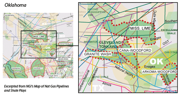
The Cana-Woodford (also known as the Anadarko-Woodford) is a liquids rich shale formation that is named after Canadian County, OK, although the formation underlies several counties in the western half of the state. Production in the Cana-Woodford kicked off in the 1930s from conventional vertical wells, with the industry’s first horizontal well coming in 2007. More recently, however, the counties that comprise the Cana fairway have been targeted for emerging oil plays, such as the SCOOP and STACK formations.
The Cana is a relatively deep formation, ranging from 8,000′-16,000′ in true vertical depth, with some wells reaching total measured depth greater than 20,000′. In 2011, the U.S. Energy Administration went so far as to declare the Cana-Woodford the deepest commercial horizontal shale play in the world. Similar to the Eagle Ford and the Ohio-Utica formations, the Cana features a dry gas, a condensate, and an oil window. Much of the industry activity in the Cana has been in the more liquids rich portions of the play. In early 2015, Continental Resources completed its first well in the northwest Cana-Woodford via a joint development agreement with a subsidiary of South Korea’s SK Group aimed at natural gas drilling (see Shale Daily, May 7, 2015; Oct. 27, 2014).
Unlike the Bakken Shale, which features a large number of operators, several of whom have amassed land holdings of more than 500,000 net acres, the majority of Cana-Woodford acreage is held by just a handful of companies, most notably Devon Energy, Newfield Exploration, Continental, Marathon Oil, and Cimarex Energy.
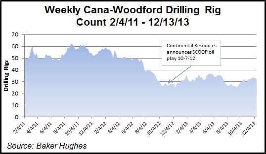
Overall drilling rig counts in the Cana started to decline in July 2012, quite possibly as operators finished drilling to hold and delineate acreage, and because of lower gas prices, but have leveled off more recently. There were 37 rigs operating in the play in early October 2015, flat from a year earlier. But a deeper dive into that data suggests that not all those rigs are actually targeting the Cana-Woodford, per se. According to Baker Hughes data, 17 of those 37 rigs were focused on oil targets in Grady County, most of which are likely targeting the SCOOP formation. Fourteen of the remaining 20 rigs were focused on oil targets in Blaine and Canadian counties, meaning they were more likely focused on the STACK plays. Only three rigs targeted natural gas. For more information on these two areas, please see Oklahoma Liquids Plays.
The Sooner Trails Pipeline proposed by Southern Star Central Corp. and a unit of NextEra Energy Inc. would connect receipt points in the Cana-Woodford footprint and elsewhere in central and southern Oklahoma with interstate and intrastate natural gas pipeline markets in Bryan County, OK, and Lamar County, TX (see Shale Daily, Aug. 20, 2015). Potential receipt points include DCP Okarche Plant, OFS Canadian Valley Plant, Enlink Cana Plant, Enable South Canadian Plant, DCP Chitwood Plant, OFS Knox Plant, Enable Bradley Plant, Woodford Express Grady Plant, and alternates. The primary points of delivery would be at the Bennington and Lamar hubs, with potential interconnects at NGPL, Midcontinent Express Pipeline, Gulf Crossing Pipeline, ETC Fuels, ETC Houston Pipeline, Enlink Crosstex and Kinder Morgan North Texas Pipeline. The 250-mile pipeline would provide up to 1.2 million Dth/d of capacity to serve local distribution companies, industrial end-users, power generators and other regional demands. Assuming regulatory approval, Southern Star and NextEra anticipate Sooner Trails service to begin in early 2018.
In addition, Enable Gas Transmission began conducting a binding open season in November 2015 for its proposed Cana & Stack Expansion (CaSe) to provide additional natural gas takeaway capacity from the Cana and the STACK. Initial capacity would be between 190-490 MMcf/d.
Oklahoma regulators have been cutting back the volume of drilling wastewater that operators may inject into disposal wells in two counties just outside the Cana-Woodford’s eastern edge in response to induced seismicity that has been blamed on such wells (see Shale Daily, Aug. 4, 2015). The Oklahoma Corporation Commission’s Oil and Gas Conservation Division plan affects northern Oklahoma and southern Logan counties.
Counties
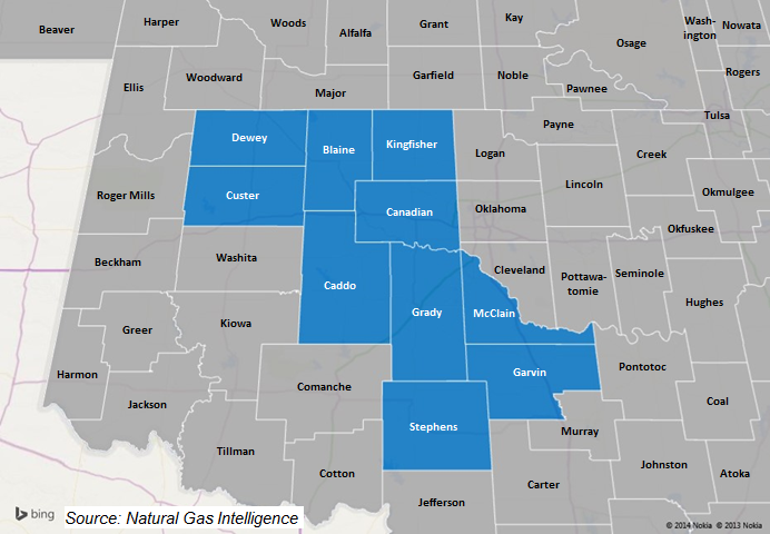
Oklahoma: Blaine, Caddo, Canadian, Custer, Dewey, Garvin, Grady, Kingfisher, McClain, Stephens
Local Major Pipelines
Natural Gas: CenterPoint Energy, Enable Gas Transmission’s Cana & STACK Expansion (proposed), Enogex, NGPL, OGT, OkTex Pipeline, Panhandle Eastern, Sooner Trails (proposed), Southern Star
Crude Oil*: Basin, Centurion, Cherokee, CK Red River, Phillips 66
NGLs: Southern Hills
*The Cana-Woodford itself is not much of an oil target, but the SCOOP & STACK formations that lie within the Cana fairway certainly are. For more on these two formations, please see Oklahoma Liquids Plays.
More information about Shale Plays:
Utica | Permian | Bakken | Tuscaloosa Marine Shale | Haynesville | Rogersville | Montney | Arkoma-Woodford | Eastern Canada | Barnett | Eaglebine | Duvernay | Fayettville | Granite Wash | Horn River | Green River Basin | Lower Smackover / Brown Dense Shale | Mississippian Lime | Monterey | Niobrara – DJ Basin | Oklahoma Liquids Play | Marcellus | Eagle Ford | Upper Devonian / Huron | Uinta | San Juan | Power River | Paradox
 Shale Daily
 Shale Datafeed