Markets | NGI All News Access | NGI Data
Cash Broadly Mixed, But Futures Discount Weather Shift
Spot gas for weekend and Monday delivery was mixed in Friday’s trading. Gains at Gulf Coast points contrasted with a weak Northeast and a mixed Great Lakes, Midcontinent, Rockies and California.
The gains posted by the September futures contract proved to be short-lived as traders saw little in the way of events that could provide any kind of meaningful turnaround. At the close, September had fallen 4.3 cents to $3.798 and October was down 4.5 cents to $3.822. September crude oil dropped 29 cents to $97.88/bbl.
Forecasters are calling for a return to more summer-like conditions. “While persistent waves of cool weather have some people in the Midwest and East saying that 2014 is the year without a summer, a forecast pattern change during August could have people thinking otherwise,” AccuWeather.com said in a report. “A shift in the jet stream is forecast during the middle of August that will lead to longer-lasting warm weather over much of the eastern two-thirds of the nation and less extreme heat over the Northwest. The jet stream will split apart prior to fully flattening out and will allow some warmth to build from the Tennessee and Ohio valleys to the East during the middle of next week,” meteorologist Paul Pastelok said Friday.
“Only brief, limited cooling is likely for parts of the Central and Eastern states later next week. During the middle of the month, an area of warm air and generally fair weather is forecast to build westward from the Atlantic. This system is known as the Bermuda High. It is possible that during the period from around Aug. 14 to Aug. 24 areas in the Midwest, Texas and the Northeast will have their warmest weather of the summer.
“The pattern shift may be most dramatic for those over the Central states, where the cool conditions thus far this summer have been the most extreme.”
In the near term, temperatures over the weekend and into Monday over a broad stretch of the country were expected to struggle to get above seasonal norms. AccuWeather.com predicted that the 70 degree high in Boston Friday would climb to 73 Saturday and reach 78 Monday. The normal high in Boston is 81. Cleveland’s Friday high of 83 was expected to drop to 77 Saturday but recover to 82 by Monday. The normal early August high in Cleveland is 82. St. Louis’ Friday maximum of 87 was predicted to fall to 85 Saturday before jumping to 90 on Monday.
Weekend and Monday gas at the Algonquin Citygates fell 16 cents to $2.36, and deliveries to Iroquois Waddington shed 28 cents to $3.36. Gas on Millennium was flat at $2.13.
In the Mid-Atlantic and Appalachia, gas was mostly lower. Gas bound for New York City on Transco Zone 6 shed a dime to $2.17, and parcels on Tetco M-3 were down by 7 cents to $2.17.
Gas for the weekend and Monday on Columbia Gas TCO rose 2 cents to $3.74, and packages on Dominion South changed hands at $1.99, down 5 cents.
Midwest quotes were mixed. At the Chicago Citygates, parcels came in at $3.79, up 3 cents, and on Alliance gas added 2 cents to $3.79. Consumers was down a penny to $3.84 and Michcon was flat at $3.85, but gas at NNG Demarcation rose 4 cents to $3.79.
Despite Thursday’s gains, traders see the dynamic of ongoing deficit contract as the primary price driver.
“[B]elow-normal trends are still anticipated across a broad portion of the U.S., with some views stretching to mid-August. This will help to maintain the dynamic of deficit contraction that has been developing this summer in dramatic fashion,” said Jim Ritterbusch of Ritterbusch and Associates. “Despite some moderation in the temp views later next week, we still see a growing likelihood of a season-ending supply of around 3.6 Tcf or more. Renewed production growth is becoming apparent and will accommodate a season-ending supply level significantly less than the five-year average of 3.83 Tcf. Meanwhile, occasional minor tropical storm threats continue to dissipate, and a need to erase some hurricane premium out of the fall contracts may be required with the arrival of August.”
Ritterbusch sees enough speculative capital available to push the market still lower. “While the recent slowing in downward momentum may be suggesting some selling exhaustion, we still feel that the money managers have excess capital to employ toward the short side of this market. Dynamics drive price direction in any commodity, and until the natural gas supply-usage dynamic begins to shift via above-normal temperature trends, placing a bottom in this market could remain elusive.”
He also sees a chart test of $3.72 in the cards and said that the market needs to factor in two additional plump storage builds along with increased production.
Additional stout storage builds notwithstanding, some see a market bottom looming. “The market signals indicate we are likely near a floor for the natural gas market,” said Phillip Golden, director of risk and product management at Energy Market Exchange in Houston. “While the market may come off further, EMEX puts the risk to the upside and would advise clients to give serious thought to taking advantage of the market fall which has occurred over the past month.
“We will still need injection numbers of 80 Bcf/week to refill storage to the levels expected by the Energy Information Administration and to get to the high of 2012, we would need to average 114 Bcf/week. While the record builds are helping us make up the storage deficit, the misses to the low side with mild summer weather is some cause for concern about how strongly the market will continue to build.”
There seems to be no end in sight to the widening negative Marcellus spot market basis to the Henry Hub. NGI Daily Cash Market Prices July 31 show a gaping -$2.42 basis on Transco-Leidy Line and a similar -$2.54 basis on Tennessee Zone 4 Marcellus.
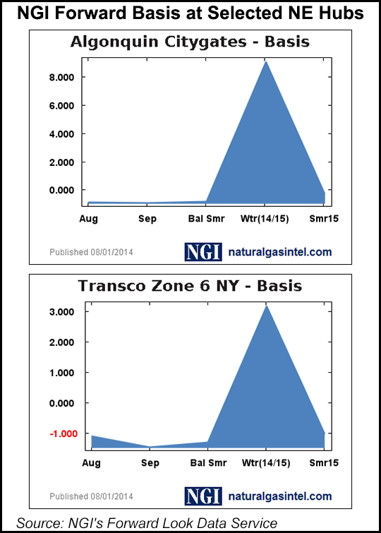
Those negative Northeast basis values are also showing up in the forward market, although the gaps are somewhat narrower. According to NGI’s Forward Look data posted Friday, August basis at Transco Z6 NY was -$1.094 and Algonquin Citygate was -$0.859. However, looking ahead into the winter months, both of those locations turn dramatically positive this winter (see chart) with basis topping $3 and $9 respectively.
Natgasweather.com said, “the latest weather models are still coming in, but what we have seen is in line with our forecast of warming temperatures the next couple of weeks, especially over the southern U.S., including the high-demand states of Texas, Oklahoma and California. With temperatures warming into the mid 90s and 100s, cooling demand will be quite strong and could support prices regionally. The northern U.S. will still see weather systems tracking through, although they will be quite a bit milder than the recent string of cool blasts.
“What is important is strong bearish headwinds will be easing over the coming weeks, apart from next week’s much larger than normal build that will be factoring in this week’s impressive cool blast.”
The National Hurricane Center in its 5 p.m. EDT Friday report said Tropical Storm Bertha was lumbering to the west-northwest at 24 mph and was holding winds of 50 mph. The storm was 405 miles southeast of San Juan, Puerto Rico and NHC projections showed it hitting the Bahamas and veering to the Northeast.
© 2024 Natural Gas Intelligence. All rights reserved.
ISSN © 1532-1231 | ISSN © 2577-9877 |