Cleon Impacting U.S. Natural Gas Imports, with Dion on Its Tail
Winter Storm Cleon on Friday was creating a “significant ice event” from the Great Plains through the Interior, with snow expected to move into the Northeast by early Saturday, the National Weather Service (NWS) said. On its heels is twin brother Dion, which into Monday was expected to deliver a second punch of wintry weather from the Pacific Coast all the way to the Northeast.
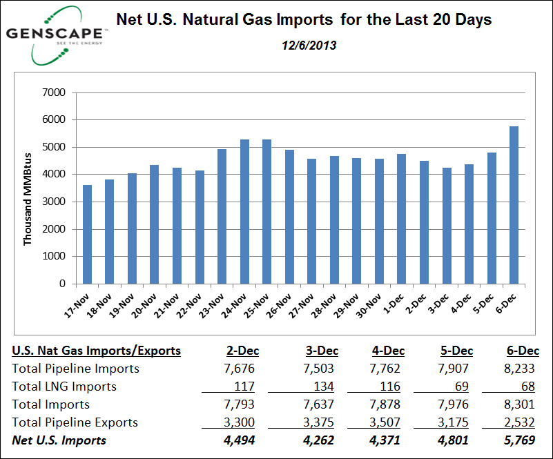
Natural gas pipelines in the path of the storms were running at capacity, continuing to issue critical notices warning shippers against overtakes (see Daily GPI,Dec. 5). The deadly storm also was impacting U.S. net imports of natural gas, according to Genscape Inc. Data indicated a spike to 5,769 MMBtu on Friday from 4,801 MMBtu on Thursday — a 20% increase.
Critical notices were posted or updated on many natural gas pipeline bulletin boards Friday, according to a review by NGI staff.
El Paso Natural Gas Co. LLC (EPNG) said there was a “strained operating condition” on its system with an imbalance tolerance of 10%. An “immediate response” may be required of its shippers because of the storm, it said in a notice announcing an operational flow order.
“EPNG continues to work toward maintaining higher linepack as the forecasted winter weather settles into our service area…Currently, the EPNG system linepack is at 7,727 MMcf; however, continued drafting of the system will undermine our ability to maintain linepack at these higher levels in anticipation of supply underperformance associated with the winter weather that is expected to continue on into early next week…
“Supply underperformance is anticipated in both the San Juan and Permian basins as a result of the extremely cold temperatures [Friday night],” EPNG said. “San Juan supply basin is currently performing at 100% of scheduled volume. Permian/Waha supply basin is currently performing at 90% of scheduled volume.”
EPNG said an “immediate action” was required to ensure that it could “continue to maintain linepack at a higher level due to the winter weather across the entire service area…Washington Ranch is on maximum withdrawal. Underperformance caps have been placed and will continue to be placed on underperforming supplies.”
Kern River Gas Transmission Co., designed to deliver up to 2.17 Bcf/d from southwestern Wyoming to California’s San Joaquin Valley, said linepack decreased another 33,000 Dth from Thursday to Friday “due to supply shortages and drafting by delivery point operators. Extremely low temperatures are expected to continue into next week. Kern River continues to work with the receipt point and delivery point operators to ensure that drafting does not continue. Customers should ensure that physical receipts and deliveries match.
“If line pack continues to decrease and system integrity is jeopardized, Kern River will take whatever actions are necessary.” Receipt and delivery point operators that owed Kern River imbalance gas were urged to arrange payback.
“Kern River’s throughput has been impacted by weather-related issues with supplies,” a spokesperson said. “However, Kern River’s system is operating normally and we are receiving and delivering all volumes that are nominated by our shippers and confirmed by supply- and delivery-side operators.”
“Supplies entering Kern River’s system in Wyoming and Utah were impacted, according to the Kern spokesperson. “We’re never entirely sure of the exact cause just because we have supplies coming from numerous sources and there are multiple processes that every Dth goes through before entry into our system. However, I do believe all were weather-related.”
PG&E Corp.’s California Gas Transmission (CGT) called for a local curtailment effective Friday because of “much lower than normal temperatures,” and said “there is a high likelihood that curtailments may be necessary through Monday…It is critical that customers impacted by curtailments utilize gas less than or equal to their maximum allowed usage..In order to protect its system, PG&E may temporarily shut off gas service to any customer that fails to comply with the curtailment order.”
“Due to the current cold weather in the supply region,” Natural Gas Pipeline Co. said Friday, shippers were advised to “verify with their suppliers that full nominated volumes are available to be delivered into Natural. Natural will request receipt point operators to reduce nominations to match what is physically being delivered during this period of cold weather. Points not flowing on rate will have nominations scheduled down.”
Natural Gas Pipeline Co., a primary delivery pipe to Chicago, said Friday that until further notice it was at capacity for gas storage withdrawals, and it said withdrawals above withdrawal quantity for delivered firm storage service (DSS) and nominated firm storage service (NSS) would not be scheduled. Additionally, it said capacity for storage injections and injections for DSS and NSS in all zones on both its Amarillo and Gulf Coast systems would be scheduled. The pipeline also indicated that until further notice it would not require in-path transportation for NSS storage injections on the Gulf Coast or Amarillo systems.
WBI Energy Transmission, which serves Williston Basin operators, said in a posting that multiple line sections were in critical condition because of capacity constraints.
TransCanada Corp.’s Nova Gas Transmission system in Alberta on Friday said there was a “potential for an Alberta System tolerance change due to supply demand imbalance leading to low linepack.” The ABC Border issued an IT restriction that indicated a capacity constraint resulting authorization of 52.7% of nominations.
Citing the weather and anticipated high demand, Spectra Energy’s Texas Eastern Transmission (Tetco) said it would require, effective at 9 a.m. Monday, that all delivery point operators in Market Area M3 keep actual daily takes out of the system less than or equal to scheduled quantities, regardless of their cumulative imbalance position.
“Freeze-offs are taking place as the Rockies and Central U.S. experience colder than normal weather,” said Genscape analysts. “Midcontinent production dropped by 1 Bcf/d in the past three days.”
Even California has not been immune to the cold.
California gas demand “stayed above 10 Bcf/d for two days in a row,” said Genscape analysts. “The demand increase has prompted huge storage withdrawals…Rockies storage withdrawals stayed above 0.5 Bcf/d in the past three days due to production level decline,” they said Friday morning.
“It is not so much that it has never gotten this cold in the region before, but rather it rarely gets this cold this early in the winter season,” AccuWeather.com’s Ken Clark said of the West Coast.
The physical demands of moving gas in and around cold-stricken areas has distorted normal pricing arrangements in California as well. “Gas for delivery Friday at the PG&E Citygates rose 13 cents to $4.40, and gas at the SoCal Citygates added 12 cents to $4.37. Deliveries to SoCal Border points added 21 cents to $4.42, pushing SoCal Border over Citygate and gas on El Paso S Mainline rose 17 cents to $4.61,” according the NGI price survey.
As of Friday afternoon, more than 200,000 customers, mostly in North Texas were without power.
The operator of the electric transmission grid for most of Texas said there would be enough power to handle usage during the winter storm sweeping across the state. But Electric Reliability Council of Texas spokeswoman Robbie G. Searcy said it may ask customers to cut their usage should there be significant failures at power plants.
Searcy had said in an email Thursday that power generators were asked to implement plans for inclement weather and to make plants available that previously were scheduled to be offline for maintenance.
The Weather Channel launched STORM:CON this year to provide a winter impact index on a scale of 1-10 for major cities within the path of winter storms, with No. 10 for extreme events, such as the “Snowmageddon” in early 2010 (see Daily GPI,Feb. 8, 2010). Those extreme storms are reserved for debilitating storms that may occur once or twice a year. An 8-9 impact, typically reserved for the biggest storms that might occur three to four times a year, would close commerce/travel for multiple days. A 6-7 storm would close commerce and travel for a day or less.
Based on the index, Dallas was at 8 on Friday, while Little Rock, AR, and Memphis were at 7. Tulsa, Oklahoma City and Columbus, OH, were ranked 6; Indianapolis, 5; and Pittsburgh, 4.
Cleon was into “Phase II” as of Friday, according to the NWS. In the Southern/Central Plains through the Ohio Valley, a narrow band of ice and sleet about 50-100 miles wide was creating ice accumulations up to three-quarters of an inch.
“There is potential that some locations within this band could see as much as one inch of ice accumulation, which would result in widespread power outages,” said The Weather Channel meteorologists. North from Oklahoma through southern Missouri, Indiana and Ohio, a 50-100 mile wide band of snow was expected to accumulate as much as five to eight inches, impacting Oklahoma City, Tulsa, St. Louis, Indianapolis and Columbus through Saturday morning.
As Cleon exits stage right on Saturday, Dion was expected to following in its wake along roughly the same track, bringing a second band of icing and snow, meteorologists said.
“Accumulations are expected to be far less; however, none of the ice that accumulates from Cleon will melt because surface temperatures are forecast to remain below freezing,” said The Weather Channel. “Therefore, impacts could be significant due to the additional weight of the added ice. The snowfall is expected to be farther north from Nebraska through Iowa and Southern Minnesota with amounts generally in the three-to-five inch range.”
“Significant icing” was possible on the western side of the Appalachian Basin “as cold air gets dammed up against the mountains and sets up a freezing rain event.” The Interstate 81 corridor in Virginia through Maryland “could see significant impacts and cities such as Raleigh, Philadelphia and even Washington, DC, and Baltimore are likely to see a wintry mix Sunday through Sunday night. By Monday, the Interstate 95 corridor should be warm enough for precipitation to be all rain.”
© 2024 Natural Gas Intelligence. All rights reserved.
ISSN © 1532-1231 | ISSN © 2577-9877 |