Infrastructure | Markets | NGI All News Access | NGI Data | NGI The Weekly Gas Market Report
El Nino Pattern Could Determine Winter Natural Gas Prices
Natural gas markets appear to be buying into multiple weather forecasts calling for a mild winter thanks to a strong El Nino pattern, as winter prices are sitting well below year-ago levels and some markets are even sporting a $2 handle.
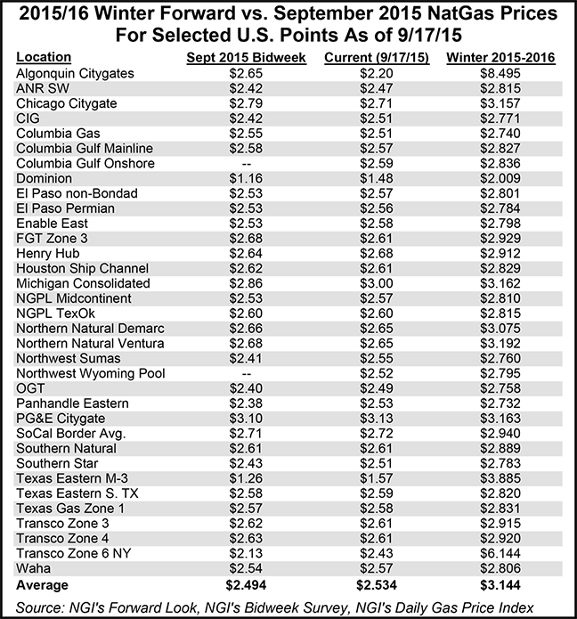
Nymex winter 2015-2016 prices averaged $2.91 as of Sept. 17, down nearly 30 cents from the average price during the winter of 2014-2015.
Other markets along the Gulf Coast, as well as those in California, the Rockies and the Pacific Northwest, also have winter prices averaging in the $2 area, according to NGI’s Forward Look.
Houston Ship Channel winter 2015-2016 prices sat Sept. 17 at $2.83, down 28 cents from last year. California Border winter prices averaged $2.94, 21 cents below year-ago levels, while Northwest Pipeline-Wyoming winter prices averaged $2.80, 18 cents below year-ago levels, Forward Look data shows.
NWP at Sumas, WA, shows the upcoming winter averaging $2.76, down 14 cents from last winter, according to Forward Look.
The National Oceanic and Atmospheric Administration, AccuWeather and other weather groups are all calling for a strong El Nino pattern to continue through the winter, which means mild temperatures for key markets such as the Northeast and Midwest and the potential for heavy rains in drought-stricken California.
El Nino is a warming of the Pacific Ocean that historically occurs about every three to five years, and this year, temperatures in the Pacific are coming in at near-record levels.
“Historically, these stronger El Nino events produce very warm winters across the major energy-demand centers of the northern U.S., and this is what energy investors and utilities are banking on at the moment,” said Todd Crawford, chief meteorologist at Weather Services International (WSI), a division of the Weather Company.
Indeed, even natural gas markets in the Northeast, a region known for its volatility during the peak winter months, are reflecting confidence in the mild winter outlooks, posting the steepest discounts to year-ago levels across the United States.
For example, the fixed price for the upcoming winter at the constrained Algonquin Gas Transmission citygates in New England averaged $8.49 Sept. 17, a whopping 87 cents below where winter prices averaged last year.
This past week alone, the Algonquin winter price plunged some 44 cents, thanks to mild temperatures on tap for next week after a brief cold front over the weekend.
A similar trend played out in New York, where winter 2015-2016 prices tumbled 26 cents this week to $6.14, which is 85 cents below year-ago levels.
“Next week will start with the cool blast over the Northeast fizzling, while warm high pressure over the central and southern U.S. expands to again cover much of the country with temperatures becoming several degrees above normal,” forecasters with NatGasWeather said, adding that the next opportunity for more impressive cold weather will be around Oct. 1.
A Northeast trader said headlines about the El Nino weather pattern are dominating the industry right now, driving much of the sell-off that was seen in the markets during the week.
There’s also some new infrastructure in place to move gas to high-demand markets, and regions such as New England that lack adequate infrastructure will continue to manage winter with reliability plans like the one implemented the last few years by New England’s electric grid operator, the trader said.
“There’s no fear for now,” the trader said.
But if history is any indication, weather is always a gamble, especially when it comes to peak seasons like winter.
In fact, Jacob Meisel, chief meteorologist at Bespoke Weather Services, said most guidance shows the El Nino peaking in the coming one to three months and decaying later in the winter season.
“Were this to occur, we would be looking at a late-season cold risk across the eastern half of the United States that could support natural gas prices,” Meisel said.
“With prices at these lower levels, we feel the natural gas market has significantly priced in the mild El Nino winter that is expected,” he said. “A typical El Nino pattern would feature cooler weather across the South and warmer weather across the North; we feel that it is possible the upcoming El Nino may transition into a hybrid Modoki El Nino, with cooler waters off of South America, which is what we are currently monitoring now. Should this occur, we would still expect relief to the California drought early in the winter, but also the potential for more cold risk across the eastern U.S.”
WSI’s Crawford also is not ready to turn the whole winter over to the El Nino influence. The agency has seen evidence this summer that the polar vortex may be very receptive to what are called “blocking events,” which effectively split the polar vortex into pieces and allow these pieces to move southward into the mid-latitudes, resulting in colder winters, he said.
“At WSI, we’ve found that strong July blocking episodes (as we had this summer) are often followed by similar strong blocking episodes the following winter, which typically lead to colder winters, as Arctic air is pulled down from the higher latitudes,” Crawford said. “So the potential winter blocking would result in a winter that is somewhat opposite to the typical warmer strong El Nino pattern.”
Still, given the limited sample of strong El Nino events, Crawford said WSI’s uncertainty is still quite high. “Remember, we only have 65 years of high-quality El Nino data to work with, and have only had six strong events during that time. And we know even less about atmospheric blocking.”
And The Old Farmer’s Almanac said in its winter 2015-2016 outlook that this season was shaping up to be a repeat of last year.
The publication called for unseasonably cold conditions over the Atlantic Seaboard, portions of the Great Lakes, and the lower peninsula of Michigan, Ohio, Kentucky, most of the Tennessee and Mississippi Valley, as well as much of the Gulf Coast.
“It’s like winter deja vu,” said Farmer’s Almanac Editor Peter Geiger.
Farmer’s Almanac is also predicting that an active storm track will bring above-normal precipitation to the Southeast States, as well as the Mississippi Valley, Southern Great Plains, the Gulf Coast, and along the Atlantic Seaboard. The Pacific Northwest, which suffered a below-average rainfall season last year, will also see above-normal precipitation.
Meanwhile, the Northeast and Mid-Atlantic States are expected to see several winter storms with a good amount of snow.
“We are “red-flagging” the second week of January and the second week of February for possible heavy winter weather with a long, drawn-out spell of stormy weather extending through much of the first half of March,” Geiger said.
© 2024 Natural Gas Intelligence. All rights reserved.
ISSN © 1532-1231 | ISSN © 2577-9877 | ISSN © 1532-1266 |